Local Government
South Perth
Region
Metropolitan
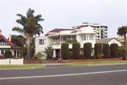
27 South Perth Esp South Perth
Dyer Residence
South Perth
Metropolitan
Constructed from 1938
| Type | Status | Date | Documents |
|---|---|---|---|
| (no listings) |
| Type | Status | Date | Documents |
|---|---|---|---|
| RHP - Assessed - Below Threshold | Current | 27 May 2005 |
| Type | Status | Date | Grading/Management | |
|---|---|---|---|---|
| Category | ||||
| Classified by the National Trust | Classified | 08 Jul 2002 | ||
The place was demolished in late May 2005.
| Name | Type | Year From | Year To |
|---|---|---|---|
| WG Bennett | Architect | - | - |
| Library Id | Title | Medium | Year Of Publication |
|---|---|---|---|
| 7410 | Report on development options for existing residence, No. 27 ( Lot 7&Pt. Lot8) The Esplanade South Perth. | Heritage Study {Other} | 2005 |
Individual Building or Group
| Epoch | General | Specific |
|---|---|---|
| Present Use | RESIDENTIAL | Two storey residence |
| Original Use | RESIDENTIAL | Two storey residence |
| Style |
|---|
| Inter-War Art Deco |
| Type | General | Specific |
|---|---|---|
| Roof | TILE | Terracotta Tile |
| Wall | BRICK | Painted Brick |
| General | Specific |
|---|---|
| DEMOGRAPHIC SETTLEMENT & MOBILITY | Settlements |
This information is provided voluntarily as a public service. The information provided is made available in good faith and is derived from sources believed to be reliable and accurate. However, the information is provided solely on the basis that readers will be responsible for making their own assessment of the matters discussed herein and are advised to verify all relevant representations, statements and information.
This information is provided voluntarily as a public service. The information provided is made available in good faith and is derived from sources believed to be reliable and accurate. However, the information is provided solely on the basis that readers will be responsible for making their own assessment of the matters discussed herein and are advised to verify all relevant representations, statements and information.
31 South Perth Esp South Perth
South Perth
Metropolitan
Constructed from 1967
| Type | Status | Date | Documents |
|---|---|---|---|
| (no listings) |
| Type | Status | Date | Documents |
|---|---|---|---|
| (no listings) |
| Type | Status | Date | Grading/Management | |
|---|---|---|---|---|
| Category | ||||
| (no listings) | ||||
Individual Building or Group
| Epoch | General | Specific |
|---|---|---|
| Present Use | RESIDENTIAL | Conjoined residence |
| Original Use | RESIDENTIAL | Conjoined residence |
This information is provided voluntarily as a public service. The information provided is made available in good faith and is derived from sources believed to be reliable and accurate. However, the information is provided solely on the basis that readers will be responsible for making their own assessment of the matters discussed herein and are advised to verify all relevant representations, statements and information.
33-39 South Perth Esp South Perth
South Perth
Metropolitan
| Type | Status | Date | Documents |
|---|---|---|---|
| (no listings) |
| Type | Status | Date | Documents |
|---|---|---|---|
| (no listings) |
| Type | Status | Date | Grading/Management | |
|---|---|---|---|---|
| Category | ||||
| Municipal Inventory | Adopted | 28 Feb 1996 | Category E | |
Historic Site
| Epoch | General | Specific |
|---|---|---|
| Present Use | RESIDENTIAL | Single storey residence |
| Original Use | RESIDENTIAL | Single storey residence |
| General | Specific |
|---|---|
| PEOPLE | Early settlers |
This information is provided voluntarily as a public service. The information provided is made available in good faith and is derived from sources believed to be reliable and accurate. However, the information is provided solely on the basis that readers will be responsible for making their own assessment of the matters discussed herein and are advised to verify all relevant representations, statements and information.
Site
This information is provided voluntarily as a public service. The information provided is made available in good faith and is derived from sources believed to be reliable and accurate. However, the information is provided solely on the basis that readers will be responsible for making their own assessment of the matters discussed herein and are advised to verify all relevant representations, statements and information.
69 South Perth Esp South Perth
South Perth
Metropolitan
Constructed from 1939
| Type | Status | Date | Documents |
|---|---|---|---|
| Heritage List | Adopted | 25 Sep 2018 |
| Type | Status | Date | Documents |
|---|---|---|---|
| (no listings) |
| Type | Status | Date | Grading/Management | |
|---|---|---|---|---|
| Category | ||||
| (no listings) | ||||
| Name | Type | Year From | Year To |
|---|---|---|---|
| Powell, Cameron & Chisholm | Architect | - | - |
Individual Building or Group
| Epoch | General | Specific |
|---|---|---|
| Present Use | RESIDENTIAL | Two storey residence |
| Original Use | RESIDENTIAL | Two storey residence |
| Style |
|---|
| Inter-War Old English |
| Type | General | Specific |
|---|---|---|
| Wall | BRICK | Face Brick |
| Roof | TILE | Ceramic Tile |
| General | Specific |
|---|---|
| DEMOGRAPHIC SETTLEMENT & MOBILITY | Settlements |
This information is provided voluntarily as a public service. The information provided is made available in good faith and is derived from sources believed to be reliable and accurate. However, the information is provided solely on the basis that readers will be responsible for making their own assessment of the matters discussed herein and are advised to verify all relevant representations, statements and information.
• The place has aesthetic value as an intact and well detailed example of the Inter War Old English style executed in brick and tile. Internal details that remain from the original construction are likely to reflect this style. • The place has research value as an example of the common practice in Western Australia which saw a delay in the adoption of new styles of architecture. • The place has historic value for its association with the development in South Perth during the Inter War period, particularly as a result of the foreshore reclamation works. The place has social value as a demonstration of the type of home built in the Inter War period for affluent members of the community.
Double storey with attic space brick house constructed in the inter-war era Old English style presenting with Tudor influences. The house is of face brick construction with imitation half timbering. The panels in between the timber elements are filled with bricks arranged in various patterns including chequerboard and herringbone nogging. The house is of asymmetric plan form with a substantial front gable wing incorporating a double storey faceted bay element, with a faceted tiled hipped roof. The roof line to the gable is steeply pitched and clad in tile. A secondary gable feature is set back behind the main wing, incorporating the timber detailing to the façade and gable, replicating the Tudor design element. All visible windows are multi-paned casements in dark timber frames. The roof form is a combination of hips and gables, steeply pitched to provide additional accommodation. Brick chimneys are located variously around the roof, the front chimney extending up the side of the gable roof, standing tall and slender in face brick. Other chimneys are more squat in form, sitting on the ridge line of the roofs. The house is surrounded by a high brick wall which obscured the ground floor of the house.
By the beginning of the twentieth century, the houses built in South Perth were centred around Mill Point, Mends Street and the South Perth Esplanade. The houses on the South Perth Esplanade generally featured large gardens stretching to the river frontage. In between the residences, land was still used for market gardens and this use continued into the Inter War period. In the 1930s, considerable works were undertaken to reclaim and improve the foreshore of South Perth with the construction of a retaining wall along the waters edge. These improvements led to the lots along the river frontage becoming more desirable for development and several large homes were built on the Esplanade, as it was known, during this period. The road name was later changed to the South Perth Esplanade to avoid confusion with other roads of this name in the metropolitan area. This residence was built for sisters Mary Jessie Hassell (1873-1953) and May Hassell (1879-1961). The women were two of the five daughters of parliamentarian and pastoralist John Frederick Tasman Hassell (1839-1919) who owned Kendenup Station in the south west of WA. The family lived for many years in Albany and held property throughout Perth. The sisters engaged architects Cameron Powell and Chisholm to design the two storey residence. On the announcement of the successful tender by contractors, Totterdell Bros for £4431 the following description of the residence was provided. Of an Old English type in design the ground floor comprises a lounge (24ft x 17ft), dining room (18ft x 15ft) toilet room, kitchen, maid's pantry, two maids' bedrooms and bathroom, entrance porch, private porch, double garage, wood room and laundry. On the first floor there are a balcony, three bedrooms, sewing room, box room and bathroom. A sketch of the design was included in the article which demonstrates that the external form and detail of the original design is largely intact. Building of the residence was completed in stages as a separate tender was called for the brick laundry and garage in April 1940. The Hassell sisters lived at the residence until their deaths, Mary in 1953 and May in 1961. It is apparent from the Electoral Rolls that members of the Hassell family had a close association with South Perth throughout the 20th century. It has not been established who the owners or occupants of the residence were after the deaths of the Hassell sisters however aerial photographs indicate the form and extent of the residence have not changed significantly since the mid 20th century. In 1992, the original lot was reduced in size to enable access to new developments on adjacent lots. A swimming pool was constructed in the front portion of the residence at this time and the brick boundary wall was added.
Demolished
| Reserve | Lot/Location | Plan/Diagram | Vol/Folio |
|---|---|---|---|
| 105 | 83064 | 1947-345 |
This information is provided voluntarily as a public service. The information provided is made available in good faith and is derived from sources believed to be reliable and accurate. However, the information is provided solely on the basis that readers will be responsible for making their own assessment of the matters discussed herein and are advised to verify all relevant representations, statements and information.
29 South Perth Esplanade South Perth
South Perth
Metropolitan
Constructed from 1925
| Type | Status | Date | Documents |
|---|---|---|---|
| (no listings) |
| Type | Status | Date | Documents |
|---|---|---|---|
| RHP - Does not warrant assessment | Current | 26 Oct 2018 |
| Type | Status | Date | Grading/Management | |
|---|---|---|---|---|
| Category | ||||
| (no listings) | ||||
• The place is a good example of a residence designed in the Inter-War Old English architectural style
• The place is representative of the residential growth of South Perth in the Inter-War period, and is one of few places that remains extant from this period on the South Perth Esplanade
• For a period of time, the place was the residence of George Sydney Cook, a well-known veteran of World War I and the son of Australia’s sixth Prime Minister Sir Joseph Cook.
The place comprises a brick and tile house in the Inter-War Old English architectural style, on a 1047m2 Lot. The house has been extended over time, and includes an attic, entry hall, lounge, dining, 3 bedrooms, sitting room, study, kitchen, family/meals, 2 bathrooms, laundry and third W.C.
Between the wars, residential lots developed at an unprecedented rate in South Perth, as well as Como and Kensington. The design of many houses was influenced by ideas brought back from Europe and America, with Californian Bungalows and Old English Revival designs replacing the Federation architecture of pre- World War I. During the 1920s, the South Perth Municipality, like other local governments in Perth, adopted a preference for brick houses over timber houses, thus influencing the future character of the area. The population of the South Perth district rose from approximately 3,000 people in 1921 to nearly 9,000 in 1933.
Individual Building or Group
| Style |
|---|
| Inter-War Old English |
| General | Specific |
|---|---|
| DEMOGRAPHIC SETTLEMENT & MOBILITY | Settlements |
This information is provided voluntarily as a public service. The information provided is made available in good faith and is derived from sources believed to be reliable and accurate. However, the information is provided solely on the basis that readers will be responsible for making their own assessment of the matters discussed herein and are advised to verify all relevant representations, statements and information.
85 Strickland St South Perth
South Perth
Metropolitan
Constructed from 1938
| Type | Status | Date | Documents |
|---|---|---|---|
| (no listings) |
| Type | Status | Date | Documents |
|---|---|---|---|
| (no listings) |
| Type | Status | Date | Grading/Management | |
|---|---|---|---|---|
| Category | ||||
| Classified by the National Trust | Classified | 09 Jun 2003 | ||
| Name | Type | Year From | Year To |
|---|---|---|---|
| R Spanney | Architect | - | - |
Individual Building or Group
| Epoch | General | Specific |
|---|---|---|
| Original Use | RESIDENTIAL | Two storey residence |
| Present Use | RESIDENTIAL | Two storey residence |
This information is provided voluntarily as a public service. The information provided is made available in good faith and is derived from sources believed to be reliable and accurate. However, the information is provided solely on the basis that readers will be responsible for making their own assessment of the matters discussed herein and are advised to verify all relevant representations, statements and information.
Near 18 Swan St South Perth
South Perth
Metropolitan
| Type | Status | Date | Documents |
|---|---|---|---|
| (no listings) |
| Type | Status | Date | Documents |
|---|---|---|---|
| (no listings) |
| Type | Status | Date | Grading/Management | |
|---|---|---|---|---|
| Category | ||||
| Municipal Inventory | Adopted | 28 Feb 1996 | Category E | |
Historic Site
| Epoch | General | Specific |
|---|---|---|
| Present Use | SOCIAL\RECREATIONAL | Theatre or Cinema |
| Original Use | SOCIAL\RECREATIONAL | Theatre or Cinema |
| General | Specific |
|---|---|
| SOCIAL & CIVIC ACTIVITIES | Sport, recreation & entertainment |
This information is provided voluntarily as a public service. The information provided is made available in good faith and is derived from sources believed to be reliable and accurate. However, the information is provided solely on the basis that readers will be responsible for making their own assessment of the matters discussed herein and are advised to verify all relevant representations, statements and information.
Site
This information is provided voluntarily as a public service. The information provided is made available in good faith and is derived from sources believed to be reliable and accurate. However, the information is provided solely on the basis that readers will be responsible for making their own assessment of the matters discussed herein and are advised to verify all relevant representations, statements and information.
16 York St South Perth
St Joseph's Convent
South Perth
Metropolitan
Constructed from 1890 to 1900
| Type | Status | Date | Documents |
|---|---|---|---|
| (no listings) |
| Type | Status | Date | Documents |
|---|---|---|---|
| (no listings) |
| Type | Status | Date | Grading/Management | |
|---|---|---|---|---|
| Category | ||||
| Municipal Inventory | Adopted | 14 Nov 2000 | Category A+ | |
02383 St Columba's Church Group & St Joseph's Convent, South Perth
| Name | Type | Year From | Year To |
|---|---|---|---|
| Richard Dennehy, orig owner | Architect | - | - |
Individual Building or Group
| Epoch | General | Specific |
|---|---|---|
| Present Use | RELIGIOUS | Housing or Quarters |
| Original Use | RESIDENTIAL | Two storey residence |
| Style |
|---|
| Federation Filigree |
| Type | General | Specific |
|---|---|---|
| Roof | TILE | Terracotta Tile |
| Wall | BRICK | Common Brick |
| General | Specific |
|---|---|
| SOCIAL & CIVIC ACTIVITIES | Religion |
This information is provided voluntarily as a public service. The information provided is made available in good faith and is derived from sources believed to be reliable and accurate. However, the information is provided solely on the basis that readers will be responsible for making their own assessment of the matters discussed herein and are advised to verify all relevant representations, statements and information.
Constructed from 1890, Constructed from 1900
Dennehy House - Saint Joseph’s Convent has aesthetic, historic, social, rarity and representative cultural heritage significance. It would have been an imposing residence in its time, which has been adapted over time to meet the needs of the Sisters of Saint Joseph. The Sisters first came to Western Australia in 1887 and have made a valuable social contribution since that time. The building is a fine representative example of a substantial Federation residence.
Dennehy House - Saint Joseph’s Convent is a substantial two-storey Federation building, with Filigree influences. The red brick building has a projecting wing, with a deep verandah across the rest of the building on both levels. The verandahs are supported by pairs of timber posts, adorned with timber lattice work and balustrading. Rendered, painted string coursing breaks the starkness of the red brick. The roof is tiled.
The Sisters of Saint Joseph first came to Western Australia in 1887, settling in Northampton. In January 1915, Sisters, led by Sr Padua Callinan, came to this site in South Perth. The principal building at Dennehy House - Saint Joseph’s Convent, now used as the Provincial offices, was originally known as Dennehy House. In 1914 the property was purchased by the Catholic Church for the sum of £3,000 from RJ Dennehy, an architect who specialised in religious architecture. He was also responsible for the Home of the Good Shepherd in West Leederville, built 1898, and the Church of the Sacred Heart in Leederville, built 1905.
Moderate-High
Good
| Ref ID No | Ref Name | Ref Source | Ref Date |
|---|---|---|---|
| Florey, Cecil. "Peninsular City: A Social History of the City of South Perth" |
This information is provided voluntarily as a public service. The information provided is made available in good faith and is derived from sources believed to be reliable and accurate. However, the information is provided solely on the basis that readers will be responsible for making their own assessment of the matters discussed herein and are advised to verify all relevant representations, statements and information.
30 York St South Perth
South Perth
Metropolitan
Constructed from 1908
| Type | Status | Date | Documents |
|---|---|---|---|
| (no listings) |
| Type | Status | Date | Documents |
|---|---|---|---|
| (no listings) |
| Type | Status | Date | Grading/Management | |
|---|---|---|---|---|
| Category | ||||
| Municipal Inventory | Adopted | 14 Nov 2000 | Category A+ | |
02383 St Columba's Church Group & St Joseph's Convent, South Perth
| Name | Type | Year From | Year To |
|---|---|---|---|
| Richard Joseph Dennehy | Architect | - | - |
Individual Building or Group
| Epoch | General | Specific |
|---|---|---|
| Original Use | EDUCATIONAL | Primary School |
| Present Use | EDUCATIONAL | Primary School |
This information is provided voluntarily as a public service. The information provided is made available in good faith and is derived from sources believed to be reliable and accurate. However, the information is provided solely on the basis that readers will be responsible for making their own assessment of the matters discussed herein and are advised to verify all relevant representations, statements and information.
Constructed from 1908
Saint Columba’s Primary School has aesthetic, historic, social and representative cultural heritage significance. The school has a long history in the Catholic community of South Perth that started with a simple combined church and school hall in 1908. The hall was still used as part of the school in 1999. Saint Columba’s Primary School is the parish school linked to the nearby Saint Columba’s Catholic Church which was built in 1936.
Saint Columba’s Primary School is made up of a series of buildings constructed in different time periods. The original Federation buildings have been extended over time, with inter-war and post war influences evident. The Pre-Primary building is a modern construction built in 1990. Some of the buildings retain the original facebrick finish, while other buildings have been rendered and painted.
The first building on the site of the present Saint Columba’s Primary School was completed in 1908. The original teachers at the school were the Sisters of Mercy, followed by the Sisters of Saint Joseph of the Sacred Heart who established themselves in the convent in York Street in 1915. (Refer Pl No. SPCnt 1-Dennehy House). The school was then called Mount Saint Joseph’s, but changed its name to Saint Columba’s Primary School in 1938, three years after the parish Church of the same name was built. (Refer Pl No. SPCnt 7a - Saint Columba’s Church). The school remained under the principalship of the sisters for seven decades before the first lay principal was appointed in 1986. Saint Columba’s Primary School celebrated its 91st Birthday in 1999. At that time there were 235 students. The principal was Ms Loretta Gibson and the school was served by all lay staff members.
Moderate
Good
| Name | Type | Year From | Year To |
|---|---|---|---|
| Richard Joseph Dennehy | Architect | - | - |
| Ref ID No | Ref Name | Ref Source | Ref Date |
|---|---|---|---|
| Florey, Cecil. "Peninsular City: A Social History of the City of South Perth" | City of South Perth | 1995 |
| Owner | Category |
|---|---|
| Roman Catholic Archbishop of Perth | Church Property |
This information is provided voluntarily as a public service. The information provided is made available in good faith and is derived from sources believed to be reliable and accurate. However, the information is provided solely on the basis that readers will be responsible for making their own assessment of the matters discussed herein and are advised to verify all relevant representations, statements and information.
South Perth, Melville & Crawley
Milyu Nature Reserve, Alfred Cove,
Pelican Point
Melville
Metropolitan
| Type | Status | Date | Documents |
|---|---|---|---|
| Heritage List | Adopted | 16 Jun 2020 |
| Type | Status | Date | Documents |
|---|---|---|---|
| (no listings) |
| Type | Status | Date | Grading/Management | |
|---|---|---|---|---|
| Category | ||||
| Municipal Inventory | Adopted | 17 Jun 2014 | Category A | |
Landscape
| Epoch | General | Specific |
|---|---|---|
| Original Use | OTHER | Other |
This information is provided voluntarily as a public service. The information provided is made available in good faith and is derived from sources believed to be reliable and accurate. However, the information is provided solely on the basis that readers will be responsible for making their own assessment of the matters discussed herein and are advised to verify all relevant representations, statements and information.

Swan Estuary Marine Park is significant as a place of natural value, which comprises three areas – Pelican Point, Milyu Reserve and Alfred Cove – tidal flats in the Swan Canning Estuary and which are important as habitats for waders. Of the Marine Park, the Alfred Cove/Point Waylen area retains the only relatively natural and extensive estuarine wetland saltmarsh on the Lower Swan Estuary; the place is significant for that reason as well as for being one of few remaining areas of relatively undisturbed peripheral vegetation. These three places are significant as some of the most important waterbird habitats in the southwest of Western Australia and as an integral part of the wetland systems in the region; as many as 132 species of waterbirds use the area as a sanctuary and breeding ground with some species migrating from as far away as China. In terms of species, the area is significant for Australian Pelican, pied cormorant, osprey, buff banded rail, grey plover, lesser golden great knot, red necked stint, broad billed sandpiper, silver gull, Caspian tern, fairy tern and crested tern. Swan Estuary Marine Park is significant for conservation values, for recreational and commercial importance to the community, and as a place of value for education, natural history and research.
Swan Estuary Marine Park comprises natural and estuarine wetland salt marsh incorporating relatively undisturbed peripheral vegetation. The peripheral vegetation includes seagrass and wildlife, both in special purpose zones for environmental protection. The Estuary is bordered on the landward side in the Alfred Cove (City of Melville) segment by a narrow foreshore strip. That strip is vegetated and abuts or incorporates a paved walkway and bicycle path linking through the Alfred Cove area to Tompkins Park and Applecross to the east and to Troy Park, Point Waylen and Attadale to Point Walter in the west. The Alfred Cove/Point Waylen segment of the Park has been identified as a wildlife habitat important for a diversity of bird species and a small pocket of marshland, mudflats available to wading birds. The segment contains fossil deposits, freshwater gastropods and natural vegetation important to bird species for breeding, roosting, feeding and passage, all of which are relevant to international migratory birds and migratory birds as well as to nomadic and sedentary birds.
Estuaries and rivers were used by the Beeliar Nyoongars as hunting grounds and this was an area of the Wetlands which was an abundant source of yams, crustaceans, turtles and waterfowl. The surrounding areas were used as campsites. Swan Estuary Marine Park is located in the Swan River at Alfred Cove, between Attadale and Applecross and incorporates the Alfred Cove section of the Park, a total area of approximately 213 hectares. The Marine Park area comprises three areas – Pelican Point, Milyu Reserve and Alfred Cove – being tidal flats in the Swan Canning Estuary, important habitats for waders. The Alfred Cove/Point Waylen area retains the only relatively natural and extensive estuarine wetland saltmarsh on the Lower Swan Estuary and is one of only a few remaining areas of relatively undisturbed peripheral vegetation. (This documentary evidence is taken from the Australian Heritage Council Register of the National Estate database Place ID 017818.)
Relatively undisturbed and sound; some weed infestation.
| Ref ID No | Ref Name | Ref Source | Ref Date |
|---|---|---|---|
| Chambers, J. M; "The Importance of Fringing Vegetation to the Swan-Canning Estuary". | Curtin University | 1987 | |
| "The Darling System – System 6: Part ii,". Report No. 13 | E.P.A., Department of Conservation and Environment, W.A., | 1983 | |
| Cammarano, G; "Swan River as a Tourist Attraction". | Curtin University | 1987 | |
| "A Directory of Important Wetlands in Australia,". | ANCA, Commonwealth of Australia, | 1993 | |
| Bodycoate R; "Swan Estuary Marine Park' Heritage Assessment". | City of Melville; | 2007 |
| Owner | Category |
|---|---|
| Department of Environment and Conservation | State Gov't |
This information is provided voluntarily as a public service. The information provided is made available in good faith and is derived from sources believed to be reliable and accurate. However, the information is provided solely on the basis that readers will be responsible for making their own assessment of the matters discussed herein and are advised to verify all relevant representations, statements and information.